About the Mesonet
Mission: Collect and Deliver reliable, high-quality, local weather, water, and soil information across Indiana to bue used for the public good.Vision: An accessible weather, water, and soil observational network across Indiana serving all communities to enhance public safety, improve economic and resource management, and meet evolving needs.


Definition of 'Mesonet'
"Mesonet" is a blend of the words "mesoscale" and "network."
In meteorology, "mesoscale" refers to weather events ranging in size from about one mile to about 150 miles, lasting from several minutes to several hours. These mesoscale weather events, such as thunderstorms and wind gusts, might go undetected without densely spaced weather observations.
A "network" is an interconnected system.
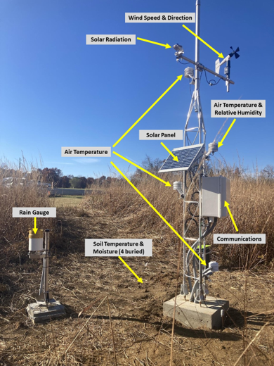
Mesonets provide high-resolution, real-time data on environmental conditions, including temperature, humidity, wind speed and direction, precipitation, and soil properties such as soil temperature and moisture at various depths. This dense and frequent data collection is crucial for improving weather forecasting, climate monitoring, and decision-making in communities across the globe. Consequently, the Indiana Mesonet aims to enhance its network to better measure and understand the environment at the scale and duration of mesoscale weather events.
For more information about Mesonets across the U.S., visit the National Mesonet website and the Mesonet Essentials website.
